2026/07/02 • An unplanned stop
► An accident on I-5 stopped traffic completely for 35 minutes.
► A 3 vehicle accident blocked the interstate just north of exit 27.
► I shot a video of some trains passing by while I was waiting to move.
Click on the photo to see more...

2026/07/02 • BNSF Railroad Bridge 9.6, Vancouver, WA
► This bridge spans the Columbia River between Washington and Oregon.
► The tallest section rotates to allow ship traffic to pass down or up river.
Click on the photo to see more...

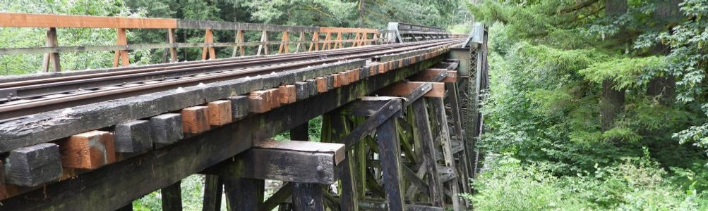
2026/07/02 • Chelatchie Prairie Railroad Bridge
► Exploring a RR bridge over the East Fork Lewis River.
Click on the photo to see more...
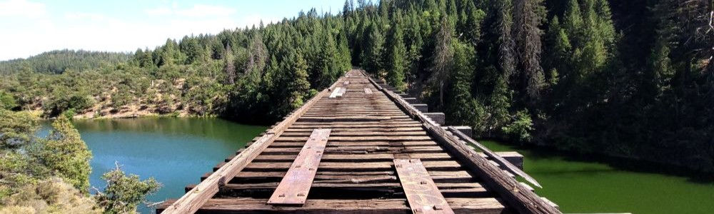
2026/06/28 • Hiking along the Chelatchie Prairie Railroad tracks
► A 2.6 mile hike in Yacolt, WA
Click on the photo to see more...

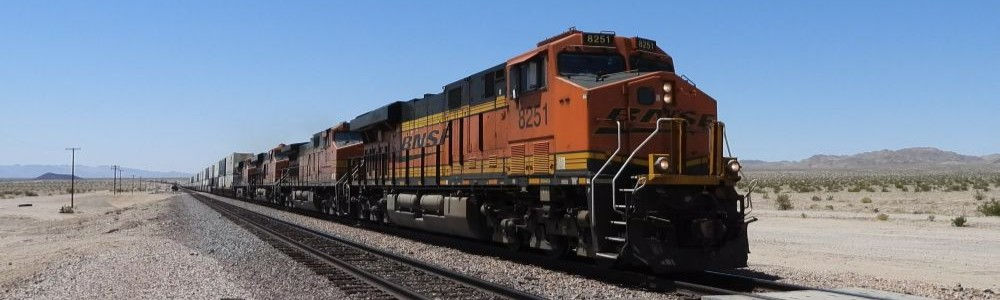
2026/05/15 • BNSF Train near Amboy, CA
► Fast moving eastbound train
Click on the photo to see the video...
2026/05/13 • Union Pacific Train at Kelso Depot, CA
► Westbound UP coming through the depot
Click on the photo to see the video...

2026/05/13 • A caboose at Boron, CA
► Along with a parked train, there was an old caboose sitting by itself on the tracks
Click on the photo to see the video...

2026/05/04 • BNSF train eastbound in Verdigris, OK
► Just happened to come across this train as I was crossing the road, and decided to film it.
► It's running along Historic Hwy 66.
Click on the photo to see the video...
.jpg)
2026/04/22 • Northbound UP train near Claremore, OK
► An empty coal train, crossing OK-88 between Claremore, OK and Oologah, OK.
► Not my best video ever...
→ shot through the windshield of my truck...
→ with bug splatters...
→ too far away...
→ you can hear my turn signal still on during the 1st 3rd of the video...
→ you can't hardly hear the train!
► I'll try to do better next time.
► And cut me a little slack, as I actually first saw this train 4 miles back, and turned and
tried to get in front of it. Just barely made it.
Click on the photo to see the video...

2026/03/15 • BNSF train north of Claremore, OK
After visiting with my son, I took the "scenic route" on my way home,
and shot a video of a train just north of Claremore, OK.
Click on the photo to see more...

2026/02/28 • BNSF train near Chelsea, OK
After visiting with my son, I took the "scenic route" on my way home,
and shot a video of a train just south of Chelsea, OK.
Click on the photo to see more...

2026/02/21 • BNSF train near Vinita, OK
Caught an east bound train on a stretch of track following Historic 66
Click on the photo to see more...

2026/02/08 • Westbound BNSF at Tiger Switch Road
I was trying to find a couple of cabooses near the industrial park in Catoosa (it actually has a Tulsa address - on Tiger Switch Rd, just west of N 170th E Ave). I found them on a spur at this location. Just after I had finished taking pics, I heard a train coming, and was able to get a video of that also.
Click here to see the cabooses on Google maps
Click on the photo to see more...

2026/02/02 • Sunset near downtown Tulsa
Found a spot near downtown Tulsa along the railroad tracks to see the sunset
Click on the photo to see more...

2025/11/14 • BNSF train going over the Verdigris River Railroad Bridge
Hiked up to the railroad to get a unique view of the train
Click on the photo to see more...

2025/11/14 • Hiking the Katy Railway Walking Trail
Cleveland, OK. 1.4 miles to the bridge.
The bridge has a burnt section of about 30' so I didn't go any further on foot.
Click on the photo to see more...

2025/10/26 • Chelatchie Prairie Railroad
Rain day. But I did bundle up and walk down to the RR tracks to see the train go by!
Click on the photo to see more...

2025/09/09 • Durango & Silverton Narrow Gauge Railroad
► Before we got started, we saw a rainbow in the clouds when we went for breakfast.
Then, after I dropped dad off at the depot, and was headed to the parking lot,
I saw 3 elk munching on plants at the local graveyard headstone shop.
► The uphill stretch. 3.5 hours, 45.4 miles, from 6,512ft to 9,302ft.
Definitely harder to breathe, and it was cooler up top. Great ride, lot's to see.
► More info about the trains here... https://www.durangotrain.com/
Click on the photo to see more...

2025/09/08 • Royal Gorge Route Railroad
► Took a railroad trip along the Arkansas River in Royal Gorge, starting in Cañon City, CO.
► About an hour out and an hour back in. It was fun.
► The video is long, sorry, it's most of the trip out.
► At one point we went under the Royal Gorge Bridge, which was our next stop.
Click on the photo to see more...

2025/08/28 • Governor's Landing Bridges
These bridges, one for cars and truck, and the other for trains, were both impressive in their own ways.
Lake Amistad is on the Rio Grande, and I made a wrong turn when I left the area from where I was flying my drone,
wasn't paying enough attention, and I almost drove into Mexico, as the road I turned on crosses the dam into Mexico!
Click on the photo to see more...

2025/08/26 • UP 8031 westbound along Old US-80
Stopped to watch this Union Pacific train heading westbound along Old US-80, near Tacna, AZ.
We probably saw at least 20 trains between Yuma and Casa Grande.
Click on the photo to see more...

2025/08/25 • Summit Scenic Overlook (Cajon Pass Overlook)
Westbound BNSF train going through Cajon Pass Summit.
Actually it was 2 trains. In the video, you will see a second train zoom by
going the same direction on the inner track. It only had a few cars.
Click on the photo to see more...

2025/07/06 • ''Stand by Me'' Bridge, CA
► Near Burney Falls, CA (which was so crowded the cars were lined up on the highway to get in) we stopped at the railroad bridge that was used in the film "Stand By Me". If you've seen the film, you'll definitely remember the scene with the train and the bridge.
► More info here... https://en.wikipedia.org/wiki/Stand_by_Me_(film)
Click on the photo to see more...
2025/07/06 • Williams Loop, Quincy, CA
► Leaving Truckee, CA, on our way to Mt. Lassen NP, we stopped at the Williams Loop, near the town of Quincy, CA on US-89. This is a train "loop" used to gain altitude in a short distance, keeping the grade to a minimum. This is similar to the Tehachapi Loop between Bakersfield, CA and Mojave, CA.
► Unfortunately, there were no trains today, BUT Geri and I did walk the entire loop, just for the fun of it!
Click on the photo to see more...

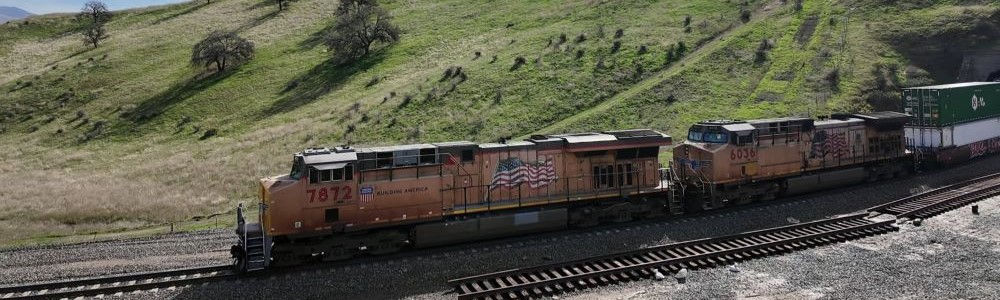
2025/07/03 • Train near Amboy, CA
► One of numerous trains near Amboy, CA. I thought I was going to melt in the 100°F heat!
Click on the photo to see more...

2025/06/29 • Train near Clayton, NM
Stopped to film a west-bound coal train.
Click on the photo to see more...

2025/05/04 • Summit Scenic Overlook (Cajon Pass Overlook)
→ Had great plans to set up multiple cameras and also fly my drone.
→ When I got here, I had my cell phone in my hand and walked to the edge so I could look down on the rails, and almost immediately a train came around the curve, so all I got was the cell phone video.
Click on the photo to see more...

2025/02/18 • West bound train at Kelso Depot
→ Got to the depot, on Kelbaker Road between Baker, CA
and Amboy, CA, just in time for this train to go by.
Click on the photo to see more...

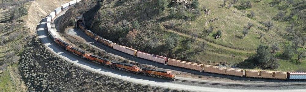
2025/02/15 • Multiple trains going through the Tehachapi Loop today
Not 1, not 2, but 3 trains captured at the Loop
Click on the photo to see more...
2025/02/15 • Tehachapi Train Tunnel 2
The 2nd tunnel on the rail line between Bakersfield, CA and Mojave, CA
Click on the photo to see more...
2024/10/24 • Video of a train near CA-66 and I-40
Stopped to shoot video of this train north of Goffs, CA
Click on the photo to see more...

2024/10/11 • Train near Amboy, CA, On the National Trails Hwy (Historic 66)
Between the towns of Ludlow, CA and Amboy, CA.
Click on the photo to see more...

2024/10/11 • Sunrise near Edwards AFB
Stopped at some railroad tracks just south of CA-58 between Mojave, CA and Barstow, CA.
Click on the photo to see more...

2024/09/17 • Saltdale Railroad Tracks
• Saltdale is an unincorporated community in Kern County, California. It is located
near Koehn Lake 21 miles south-southwest of Ridgecrest near Garlock, California.
It is at an elevation of 1,923 feet.
The town was founded in 1914 for salt harvesting from Koehn Dry Lake. (Wikipedia)
• This "town" (of which I could find no evidence) is on Redrock-Randsburg Rd,
between CA-14 and US-395, north of Mojave, CA.
Click on the photo to see more...

2024/09/14 • Gaviota State Beach
► This beach is the last one on US-101 south of Vandenburg AFB.
Got permission from the guy who took our entry fee to fly my drone.
► There is a large railroad trestle bridge that runs over the beach.
Click on the photo to see more...

2024/05/26 • Rushing home after hearing of tornado damage in OK
• A section of railroad just east of Amboy, CA also on 66
Click on the photo to see more...

2024/05/25 • Railroad Through-Truss Bridge
• Love me some through-truss bridges!
Click on the photo to see more...

2024/05/17 • Headrick Historic Steel Pony Truss Bridge
• Headrick Historic steel pony truss bridge. Old trestle bridges fascinate me.
In fact, I lost a drone at one once! Headed west toward Texas.
Click on the photo to see more...

2024/02/09 • Kelso Depot
► Between I-15 and I-40 on Kelbaker Road
Click on the photo to see more...

2023/10/13 • Tehachapi Loop
A railroad "loop" in the Tehachapi Mountains.
Read more here... https://en.wikipedia.org/wiki/Tehachapi_Loop
Click on the photo to see more...

2023/08/19 • Bodie and Benton Railroad Historical Marker
A little piece of history just north of Mono Lake and 10 miles south of Bodie State Historic Park.
Click on the photo to see more...

2023/01/27 • Cajon Pass Summit Scenic Overlook
Catching the trains going through Cajon Pass
Click on the photo to see more...

2022/07/30 • Chelatchie Prairie Railroad (BYCX)
Riding the local tourist train in Yacolt, WA
Click on the photo to see more...

2022/07/28 • Dyerville Train Trestle
One of our many stops on our way from CA to WA
Click on the photo to see more...

2022/06/05 • The MetroLink
Where it crosses the Pacific Crest Trail @ Soledad Canyon Road
Caught a video of the MetroLink as it passed over the PCT
Click on the photo to see more...

2021/08/28 • Railroad Trestle @ Gaviota State Beach
A view from just above the rails
Click on the photo to see more...

2020/12/22 • Sunset at the Railroad
Stopped to watch the sunset at some railroad tracks near Weleetka, OK.
I was on my way home from a work trip to Ada, OK.
Click on the photo to see more...

2020/10/16 • The Grand Canyon Railway
Took the Grand Canyon Railway from Williams, AZ to the south rim of the Grand Canyon.
It was a wonderful, but very tiring experience.
Click on the photo to see more...

2020/08/20 • Took a hike down the Chelatchie Prairie Railroad (BYCX)
Felt like taking a Sunday morning walk. Ended up hiking 1.5 miles down the railroad tracks
and then back again while I listed to our pastor's live-stream sermon.
Click on the photo to see more...
